
Wetlands and the Comprehensive Plan: From Inventory to Protection
Part 3 of 4 in our July series on Natural Resources and the Comprehensive Plan.
Nearly every comprehensive plan maps wetlands. Very few put them to work.
The natural resources chapter almost always includes a reference to the National Wetlands Inventory, a figure showing riverine and palustrine systems, and a general goal about “protecting wetland functions and values.” And then the plan moves on—and the next subdivision application that nibbles at a depressional wetland edge gets approved because no one connected the map in chapter ten to the criteria in chapter seven.
This July series is about closing that gap. We’ve already talked about soils and water as planning layers, not just background information. Wetlands sit right at that intersection: they are where certain soils, certain topographies, and certain hydrologies meet—and they quietly store floodwater, filter runoff, recharge groundwater, and support habitat that the rest of the landscape depends on.
The data exist. The policy tools exist. What’s missing, in most places, is the decision to treat wetlands as infrastructure in the comprehensive plan, rather than as compliance boxes on a permit form.

What Wetlands Actually Do
Before wetlands can be protected, they have to be understood — not as regulatory features on a map, but as functioning systems that provide measurable services to the communities around them.
Wetlands are areas where land is covered by water or the soil is saturated long enough for water‑loving plants and special wet soils to develop. A wetland is a semi‑aquatic ecosystem: not fully dry land, not fully open water, but something in between. Water may be present year‑round or only seasonally, yet it still shapes the soil, chemistry, plants, and animals that live there. Typical examples include marshes, swamps, bogs, and fens, found from the tundra to the tropics on every continent except Antarctica.
Three main traits define wetlands: water at or near the surface, “hydric” (water‑logged) soils, and hydrophytes—plants adapted to saturated ground. Many sit in low‑lying areas, along rivers and lakes, in coastal zones, or in small depressions where rain or groundwater collects. Because they are transitional zones between dry land and open water, they often form mosaics with streams, ponds, and uplands around them.
Scientists often group wetlands into coastal/tidal and inland/non‑tidal types. Coastal wetlands include salt marshes and mangrove swamps influenced by tides and sea water. Inland wetlands include freshwater marshes, forested swamps, peat bogs, and wet meadows, each shaped by different water sources (rain, rivers, groundwater) and chemistry (acidic vs. alkaline).
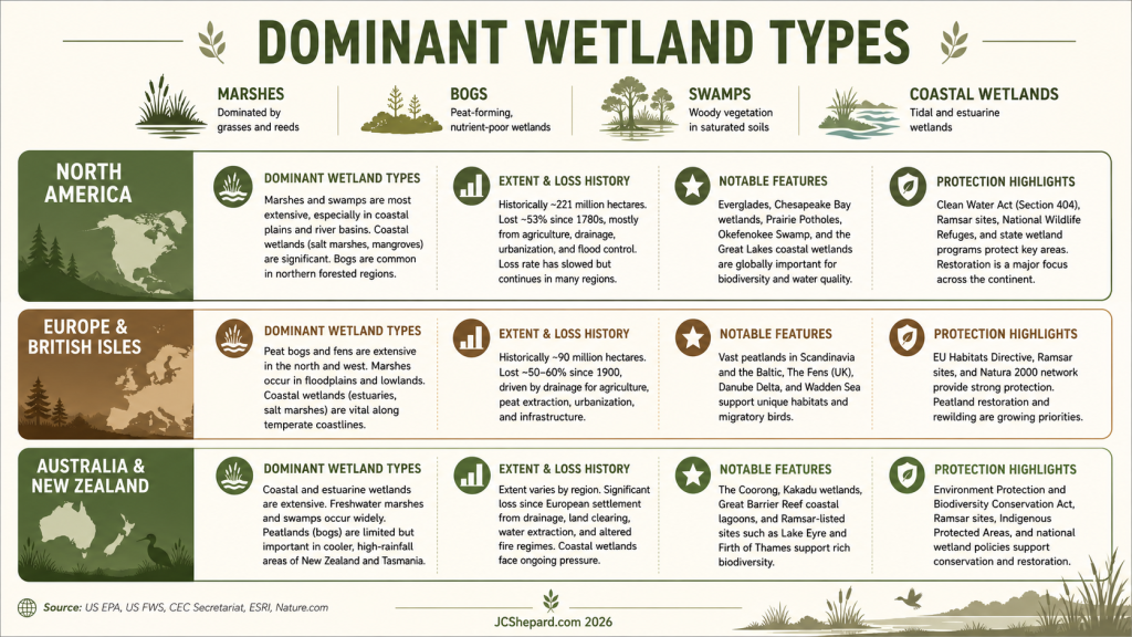
Wetlands around the world
In North America, non‑tidal freshwater marshes are the most widespread wetland type, especially across the central and eastern United States and southern Canada. The continent also supports vast northern peatlands (bogs and fens) in Canada and Alaska, forested swamps in the southeast, prairie pothole wetlands in the northern Great Plains, and tidal marshes along both coasts.epa+4
Historically, drainage for agriculture, forestry, and urbanization caused substantial losses, particularly in the lower 48 states, though large tracts remain in sparsely populated northern regions. Current policy focuses on mapping and monitoring (e.g., the U.S. National Wetlands Inventory) and on protecting and restoring wetlands for flood control, habitat, and water quality, but pressures from development and climate change persist.
Under the Ramsar Convention, Australia recognizes a wide range of wetland types, including swamps, marshes, billabongs, lakes, saltmarshes, mudflats, mangroves, and even coral reefs and shallow marine areas. Many Australian wetlands sit in floodplains of large rivers or in coastal zones, and their character reflects the continent’s generally flat relief and extensive arid interior contrasted with wetter coastal belts. Australia currently has 67 Ramsar wetlands of international importance, together covering more than 8.3 million hectares, and it was among the first countries to list a Ramsar site in 1974.
New Zealand, with its bogs, marshes, swamps, seepages, and lake‑edge wetlands, has a smaller absolute wetland area but high biodiversity importance, and the Department of Conservation manages several Ramsar wetlands as part of a national classification and planning framework.
Both countries—like many others around the world—face pressures from drainage, agriculture, and hydrological modification, but they also have strong legal frameworks focused specifically on wetland conservation.
In Europe and the British Isles, wetlands include inland marshes, wet meadows, peatlands, floodplains, rivers and lakes, as well as coastal saltmarshes, mudflats, mangroves in limited southern areas, and shallow marine habitats. Reed swamps and wet grasslands are common in temperate lowlands, while blanket bogs and raised bogs dominate some upland and oceanic climates, such as parts of Ireland and Scotland.
Europe is considered a global hotspot of historical wetland loss: average extent has declined by more than 50% since 1700, with countries like Ireland, the UK, Germany and others losing over 75–90% of their wetlands mainly through drainage and peat extraction. Even with Ramsar sites, EU biodiversity and water directives, wetlands across Europe remain in the poorest condition of any major ecosystem class, with fragmentation and ongoing degradation still widespread.
Why wetlands matter
Wetlands act like natural sponges, storing and slowly releasing rain, river water, and floodwaters, which reduces flood peaks and erosion, and adds to groundwater reserves. They filter out sediments and many pollutants, improving water quality for downstream rivers, lakes, and even groundwater—earning the nickname “kidneys of the earth.” They also store large amounts of carbon in plants and soils, helping moderate global climate and support at least one‑third of threatened and endangered species.
Flood storage. A single acre of wetland can store up to 1.5 million gallons of floodwater. In watersheds where upstream wetlands have been drained or filled, flood peaks increase downstream — often dramatically. The communities paying for flood damage are frequently not the ones that made the land use decisions that caused it.
Groundwater recharge. Many wetlands, particularly those in upland and prairie positions, contribute directly to groundwater recharge. As we discussed last week in our article on water resources and the comprehensive plan, groundwater is the primary drinking water source for most rural households. Wetlands that recharge aquifers are part of the water supply infrastructure — whether or not they appear on an infrastructure map.
Water quality. Wetlands filter nutrients, sediments, and contaminants from surface water before it reaches streams, lakes, and groundwater. In agricultural landscapes, wetland buffers along drainage ways can remove a significant portion of the nitrogen and phosphorus that would otherwise contribute to downstream water quality problems. This is not a secondary benefit — it is one of the primary reasons wetland protection belongs in the comprehensive plan alongside zoning and subdivision standards.
Wildlife habitat and ecological function. Wetlands support a disproportionate share of the nation’s biodiversity relative to their area. For local governments, this matters less as an ecological abstraction than as a practical reality: wetlands that support game species, pollinators, and native vegetation are assets to rural communities, not obstacles to development.
Yet as Joe Wagner, PE, of Savannah, Georgia, writes today on LinkedIn, “A wetland can process a load. It cannot absorb an unlimited one… Wetlands are living systems—not empty space at the end of a pipe.”
Wetlands don’t need to be protected because regulators require it. They need to be protected because the services they provide are expensive to replace — and often impossible to.
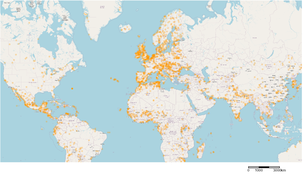
What the Inventory Is Telling You
Here in the United States, the U.S. Fish and Wildlife Service’s National Wetlands Inventory (NWI) provides more than just a picture of “wet places” — it is a national, standardized dataset that encodes how different wetlands are likely to function on the landscape. Canada has the Canadian National Wetlands Inventory (CNWI) covering about 1/3 of that nation’s land mass. Other sources I’m not as familiar with, such as the Ramsar Sites Info Service map, catalog wetlands around the world.
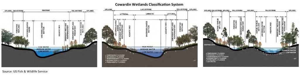
By classifying each part of a map by both wetland type (emergent, scrub–shrub, forested, aquatic bed, and more) and water regime (temporary, seasonal, semi‑permanent, permanent, tidal), the US FWS’s NWI and similar sources offer a first‑cut prediction of hydrology, habitat value, and sensitivity to disturbance without anyone yet having walked the site.
In the Nebraska plans I’ve worked on, this usually shows up as a brief tour through the Cowardin wetlands systems—marine, estuarine, riverine, lacustrine, and palustrine—with the standard US Fish and Wildlife Service cross‑sections and system diagrams dropped into the natural resources chapter. The riverine figure reminds you that many of your mapped wetlands live in channels and floodplains; the lacustrine diagram explains how reservoirs and lake basins fit into the picture; the palustrine panel is where the everyday marshes, swamps, and prairie potholes actually show up. For most readers, those graphics are the first and only time they see wetlands treated as part of a larger classification system—useful, but still disconnected from how we draw growth areas, overlays, and subdivision standards in the rest of the plan.
What that means for planning is straightforward: NWI can show you not only where wetlands are, but which ones are probably storing floodwater, which are most important to migratory birds, which are buffering streams, and which may be more or less resilient to change. An emergent wetland with a temporary water regime will respond differently to tile drainage or a driveway crossing than a forested wetland with a semi‑permanent regime, and the inventory gives you the language to name that difference on a map and in a staff report.
The missed opportunity in most plans
NWI is very much like the NRCS soil survey we discussed earlier in this series: a rich, spatial database that comprehensive plans dutifully cite and then largely ignore. The wetlands map appears in the natural resources chapter as a static figure, but the classification system—the alphabet soup of codes that translate aerial imagery into types and water regimes—is rarely unpacked for decision‑makers.
The result is a disconnect between policy and practice. Plans talk about protecting wetlands, but they seldom explain how a “PEMF” polygon on a site plan relates to those goals in plain language. Section 404 of the Clean Water Act, which regulates the discharge of dredged or fill material into waters of the United States and aims for “no overall net loss” of aquatic resources, becomes something that happens “out there” with the Corps, rather than a tool local governments understand and can complement. When staff, planning commissioners, and elected officials don’t have a framework for reading NWI codes against their own policies, they have little way to tell whether a particular impact is trivial, significant, or part of a pattern they should care about.
I don’t claim to be an expert. I don’t have all the answers. I just try to learn to ask better questions.
Few of us on the policy, land use, or economic development side have all the answers. NWI is a prompt for better questions: What kind of wetland is this? How often is it wet? Where does its water come from? What does that imply for flood storage, habitat, and water quality? Those questions are well within the competence of planning staff and boards once the codes are translated into ordinary language.
Why wetland type matters on the ground
This is where the difference between types stops being academic. An emergent wetland in a depressional position in an agricultural landscape—coded, for example, as palustrine emergent, temporarily or seasonally flooded—can apparently quietly store a surprising volume of runoff and provide critical waterfowl habitat, even if it reads as a “muddy low spot” to someone like me focused on farmability. A forested riparian wetland—palustrine forested, seasonally flooded—along a stream corridor is likely filtering nutrients and sediment, stabilizing banks, and providing shaded habitat that upstream and upland areas cannot.
Neither of those functions are visible on a standard zoning map. They don’t show up in the same way a designated floodway, a park, or a wellhead protection area does. And because NWI is rarely integrated into an overlay zone or resource‑based district, both can be filled or drained one permit at a time—each impact small enough to appear reasonable—without anyone at the county level ever seeing the cumulative trajectory. When you read the inventory in combination with your development review history, you start to see where those small decisions are nibbling away at depressional storage, riparian filters, or specific habitat types.
The cumulative loss problem, in planning terms
Section 404 permitting is built around project‑by‑project decisions, with thresholds and nationwide permits intended to ensure “no net loss” of aquatic resources at the federal program scale. Many individual impacts are small—fractions of an acre, short reaches of stream channel—and often come with mitigation requirements for larger projects. From the federal perspective, that may be workable; from the planner’s perspective, it can obscure the local pattern of change.
Comprehensive planning is supposed to take that longer, cumulative view. The planning problem is not any single culvert, driveway, or pad site; it is the aggregation of many such approvals over a twenty‑year horizon. A county that never looks at NWI data in its land‑use analysis, never maps wetland types as an overlay, and never asks applicants to show avoidance “to the maximum extent practicable” is betting that federal permitting alone will protect functions it depends on: flood attenuation, water quality, habitat, and the public costs of drainage and infrastructure.
Your two‑county thought experiment makes this tangible. In County A, NWI and soils are treated like any other planning layer: they are brought into the future land‑use map, distilled into a wetland protection overlay, and used to structure review criteria. Applicants are expected to avoid mapped wetlands when siting lots and roads, and to demonstrate why impacts cannot reasonably be designed out of the project before mitigation is considered. Twenty years later, the inventory still largely matches the ground, stormwater systems are less strained, and remaining wetlands continue to deliver the free services planners like to talk about.
In County B, mapped wetlands remain a background figure in the natural resources chapter. Development proceeds with reliance on federal Section 404 jurisdiction and mitigation to catch any serious issues, and the local plan never measures or manages wetland loss as a trend. Two decades later, NWI updates and status‑and‑trends reporting show a slow but persistent erosion of wetland coverage and function, and the county is paying for more structural flood control, more water‑quality retrofits, and emergency management planning it could have reduced by treating wetlands as part of its land‑use system.digitalcommons.
The difference, as we say, isn’t regulation. Federal law is the same in both counties. The difference is whether the local comprehensive plan chooses to treat NWI—and wetland type itself—as a meaningful layer in how it guides growth, or as a map in the back of a chapter.

From Inventory to Protection: Connecting the Map to Policy
The National Wetlands Inventory is where you start the conversation, not where you end it. Moving from inventory to protection means treating NWI data like any other core planning layer—just as real for land use decisions as your future land use map, roads, and floodplains.
Step 1: Put NWI in the middle of your maps
Bring the NWI into your GIS (if you’re in the US, or your best local data service). Then layer it on top of your future land use map, zoning map, and subdivision pattern. Don’t just check a box that “wetlands were considered”; interrogate the map. Where do growth areas, corridors, and employment centers land straight over depressional wetlands, riparian corridors, or complexes of small, scattered marshes?
Those are conflicts, and conflicts belong in the plan text and maps, not just in staff memos. If your designated growth area overlays a cluster of flood‑storage wetlands, say that explicitly in the natural resources chapter and the land use chapter. Name the trade‑off: you can keep the growth area, adjust its footprint, or shift it—what you shouldn’t do is quietly leave those decisions to be worked out one permit at a time.
Step 2: Turn the map into an overlay
Once you know where wetlands sit in relation to your planned development pattern, the obvious next step is a wetland protection overlay or conservation district. An overlay gives you a regulatory “wrapper” around mapped wetlands and their immediate surroundings without rewriting your entire base zoning.
The idea is simple: if your parcel is in the overlay, certain uses and site designs are constrained, and certain review questions are mandatory. You’re not duplicating federal law—you’re getting out ahead of it. Instead of waiting for a Section 404 application to surface the issue, you’re saying up front that in these mapped areas, applicants must demonstrate avoidance and minimization, not just compliance with national minimums. That shift in burden of proof is small on paper and enormous in practice. It moves wetlands from “something we’ll deal with if the Corps cares” to “something our comprehensive plan cares about by default.”
Step 3: Protect the edges, not just the polygons
A lot of wetland damage happens at the edge. Development stops at the boundary line, but the upland buffer that supports the wetland’s hydrology, habitat, and water quality functions is sliced away by grading, roads, and lawns. From the planner’s standpoint, that’s where buffer standards come in.
Buffers in the 50‑ to 100‑foot range are common in state and local practice, with wider distances for more sensitive wetlands, shorelands, and vernal pools. The exact numbers will vary by state law and local politics; the important part is that the standards are written into your subdivision and site plan regulations in plain language. Within the buffer, you spell out what’s allowed: trails yes, buildings no; native vegetation yes, parking lots no. You also make clear that “meeting the setback” is not the same thing as “protecting the wetland”—the buffer exists to keep the edge functioning as that sensitive transition zone.
Step 4: Make wetland review routine, not exceptional
If the only time wetlands show up in your staff report is when a particularly contentious project or neighbor complaint forces the issue, you’re already behind. The standard subdivision review checklist should explicitly ask: Does the site include or lie adjacent to mapped wetlands (NWI or local inventory)? If yes, what is the wetland type, what is the water regime, and how does the proposed design respond?
That doesn’t require a wetland scientist at the counter. It requires staff who know how to pull up NWI in the wetlands mapper or local GIS, read the basic code, and flag “this looks like a depressional emergent wetland” or “this is a forested riparian fringe.” It also requires a simple, consistent step in the workflow: when mapped wetlands are present, the site design gets a wetland paragraph in the staff report, not just a note that “all necessary permits will be obtained.”
The point is timing. Issues caught at sketch plat or preliminary plat are still design problems; issues discovered at grading permit stage are suddenly legal and engineering problems.
Step 5: Tie wetlands back to soils and water
As we covered in Week 1 on soils and Week 2 on water resources, none of these systems exist in isolation. Wetlands are where certain soils, certain topographies, and certain hydrologies intersect—in depressions, along breaks in slope, in floodplains, at groundwater discharge points.
If your comprehensive plan handles soils in one chapter, water resources in another, and wetlands in a third, it’s very easy to treat them as separate boxes. You miss the way poorly suited soils, aggressive grading, and tight lot patterns push more runoff into those mapped wetlands, and the way losing those wetlands feeds directly back into your floodplain management and drinking water goals. The fix isn’t a grand reorganization so much as cross‑references and shared maps: show the NWI on the soils map; show hydrologic features on the wetlands map; talk about buffers and overlays as part of your broader water‑quality strategy.
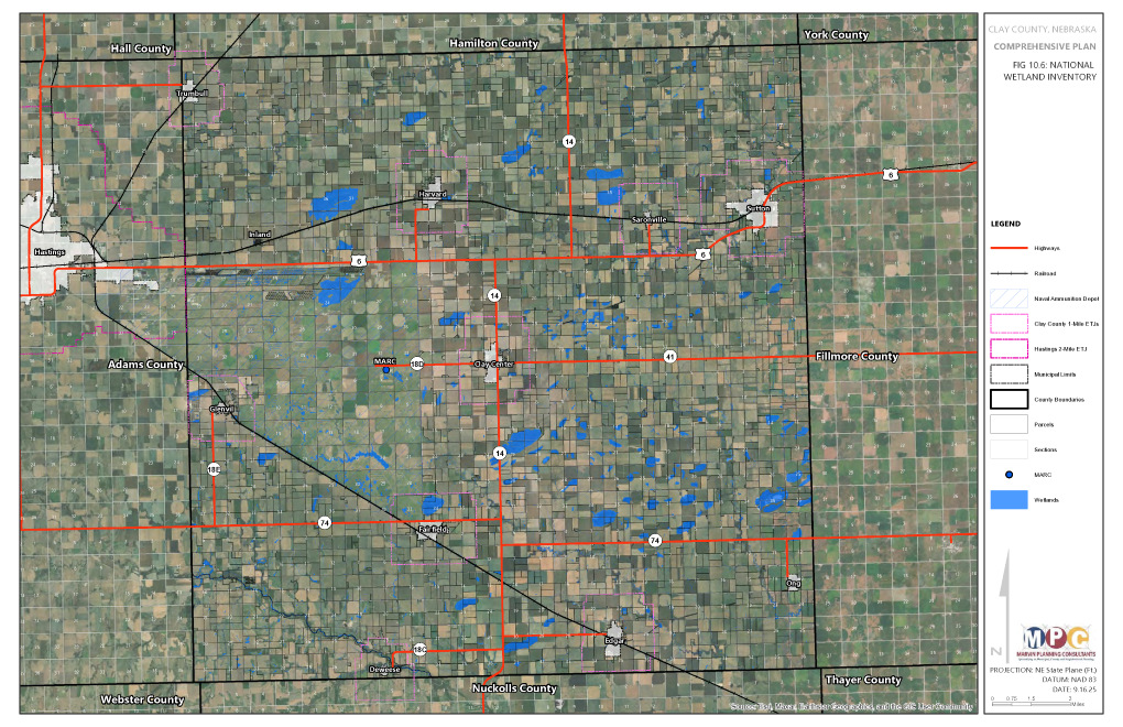
Don’t just check a box… interrogate the map
In the Nebraska counties I’ve worked with we’ve made progress on the pattern, even while acknowledging political appetite varies by jurisdiction. Each plan has a solid natural resources chapter. Each one explains what wetlands are, reproduces the National Wetlands Inventory diagrams, and maps riverine and palustrine systems along the major waterways like the Platte River. Each one sets a goal to “protect wetlands to the extent required by Federal law” and to “work with the State of Nebraska” on regulatory compliance. And that’s where we still have work to do on implementing those goals in real life.
In Thayer County, we probably come closest to the complete inventory chapter. It explains the Sackett court case, walks through the NWI systems, and maps freshwater emergent and forested/shrub wetlands along the Little Blue valley. In Clay and Jefferson counties we did the same along their streams and ponds (Clay County has a particularly large amount of wetland habitat popular with migrating waterfowl). Hall County goes a step farther by pairing wetlands with low‑impact development tools—rain gardens, bioretention, and open‑space design—in a more complex Platte River landscape at the heart of the Central Flyway.
That’s where we start to move from inventory to protection. We stop treating wetlands as a static figure in the natural resources chapter and start treating them as a living layer in your growth management framework—one that shapes where you put people, pipes, and pavement, not just where you color the map green.

Wetlands as Infrastructure
Wetlands are not regulatory obstacles. They are infrastructure—flood storage, water filtration, groundwater recharge, habitat—that took centuries to build and cannot be reconstructed once lost. Section 404 permitting and mitigation have their place, but they work project by project and jurisdiction by jurisdiction. Comprehensive planning is supposed to work across projects and across time—to notice when a pattern of small, individually reasonable approvals is quietly erasing the wetland functions the community assumed would always be there.
Communities and counties who bring NWI into the middle of their maps, adopt wetland overlays and buffers, and make wetland review routine are not “out‑regulating” their neighbors; they are choosing to see and manage cumulative impacts instead of outsourcing them. Counties that leave wetlands entirely to federal law are, in effect, delegating one of their most important land‑use decisions and paying for it later—in drainage costs, flood damage, degraded water quality, and lost habitat. The inventory already tells you what you have and how fast it’s changing; the comprehensive plan is where you decide whether those changes are acceptable. The difference isn’t regulation. It’s planning.
Next Sunday, July 26th, we close the series with conservation tools: easements, the Conservation Reserve Program, land trusts, and how to make them work alongside your comprehensive plan.
Questions about integrating wetlands into your comprehensive plan? Let me know.
Had a great discussion at the Inland Northwest Partners summer conference in Cheney, Washington, on measuring success on Main Street. Let me know if I can work with you on a keynote presentation or workshop on any of the planning and development topics we explore here at JCShepard.com. Next up: The Western Planner Conference in Sioux Falls, South Dakota, the end of August.

FURTHER READING
The wetland mapping and regulatory data referenced in this article is publicly available and already covers your county. The resources below will help you go deeper — whether you’re looking for wetland classification guidance, protection standards, or planning frameworks that connect wetland inventory to land use policy.
Tools & Data
- USFWS National Wetlands Inventory — The primary source for wetland mapping data across the United States. Wetland type, classification, and water regime data are available as GIS layers for download.
- EPA Wetlands Information — Overview of wetland functions, values, regulatory framework under Section 404, and guidance for local governments on wetland protection planning.
- USACE Regulatory Program (Section 404) — The federal permitting program for wetland impacts. Understanding what Section 404 covers — and what it doesn’t — is essential context for local planning practice.
Reports & Research
- Wetlands: Status and Trends in the Conterminous United States (USFWS) — The authoritative national assessment of wetland gains and losses over time. Provides state-level data and trend analysis essential for understanding the planning context.
- Economic Benefits of Wetlands (EPA) — Summary of research on the economic value of wetland flood storage, water quality, and habitat services. Useful for making the case to elected officials and planning boards.
- Protecting Wetlands Through Local Land Use Planning (EPA) — Practical guidance specifically aimed at local governments on integrating wetland protection into zoning, subdivision, and comprehensive planning.
Planning Guidance
- Sustaining Places: Best Practices for Comprehensive Plans (APA PAS Report 578) — APA’s framework for integrating natural systems — including wetlands — into long-range comprehensive planning.
- Conservation Design for Subdivisions — Randall Arendt’s practical guide to designing around natural features including wetlands, with specific tools for subdivision review and open space planning.
Books
- Wetlands, 6th edition — William Mitsch, James Gosselink, Christopher Anderson, and M. Siobhan Fennessy (Wiley, 2023). The standard academic reference on wetland ecology, function, and management. Dense but authoritative — the book planners cite when they need to make the case for wetland value.
- Wetland Ecology — Paul A. Keddy (Cambridge University Press, 2010). A highly acclaimed textbook providing a global perspective on wetland ecology, focusing on ecological interactions, plant communities, and conservation strategies.
- The Ecology of a Changing Planet, 3rd Edition — Mark Bush (Benjamin Cummings, 2002). Accessible overview of landscape ecology and land use change, including the role of wetlands in regional hydrology and biodiversity.
- Taming the Flood: A History and Natural History of Rivers and Wetlands — Jeremy Purseglove and Tony Soper (Oxford University Press, 1989). A practical reference on floodplain and wetland management for local governments, focused on reducing flood risk through land use rather than infrastructure.
This page contains affiliate links. As an Amazon Associate, JCShepard.com earns from qualifying purchases at no additional cost to you.
Resources
Rural-Ready Engagement: Practical Tools for Small Town Planners
 Watch the full replay: youtube.com/@Engaging-Communities (February 2026)
Community engagement can look very different in small towns and rural communities. This webcast was co-sponsored by the APA Community Engagement Interest Group and the Small Town & Rural Planning Division.
Dynamic Decisions Podcast (Season 2 Episode 15)
“Stop Chasing Smokestacks. Grow What You Have” with Teasha Cable of cModel Data, now playing on Youtube (audio), Apple Podcasts, Spotify (May 2026). Other listening links here.
The Rural Impact Podcast (Episode #86)
“Pathways to Powering Rural America” My guest spot on Michelle Rathman’s podcast. Episode page here, listen on Apple Podcasts or Spotify, or watch (!!!) on youtube. We talked about energy, data centers, and good governance, plus so much more.
Popular posts on JCShepard.com
- The Planning Process—From Vision to Action in Small Towns and Rural America (January 2026)
- Small Towns Can Build a Strong Outdoor Economy Without Selling Out (June 2026)
- Historic Preservation and Rural Economic Development: A Rural Growth Strategy (April 2026)
- Main Street America and the Revival of Downtown (June 2026)
- Natural Resources in Your Comprehensive Plan (July 2026)
- Reviving Rural America: Why Heritage Tourism Is a Game-Changer Now (September 2025)
- Soils and the Comprehensive Plan: What Your Soil Survey Is Trying to Tell You (July 2026)
- Water Resources and the Comprehensive Plan: Planning for Wells and Watersheds (July 2026)
- What is Economic Development in Modern America? A Field Guide for Small Towns and Rural Places (March 2026)
- The Rise of Rural Entrepreneurship: Building Economies from the Ground Up (January 2026 on Medium.com)
- Rural Recreation and the Outdoor Economy: Trails, Fairs, Community Identity (May 2026)
- Rural Housing Supply Crisis: Why Small Towns Are Running Out of Homes (February 2026)
- Regenerative Conservation and Community Renewal (June 2026)
- Powering Rural America: The Full Energy Picture in 2026 (June 2026)
- Community Facilities: Why We Need to Rebuild Our Foundations (April 2026)
Check out The 12 Planning & Sustainability Books You Need in 2026 and browse through the Small Town & Rural Community guides on our Resources page.
.